Super Typhoon Bavi gets local name Inday even before entry into PAR
MANILA, Philippines – The weather bureau gave Super Typhoon Bavi the local name Inday even before its entry into the Philippine Area of Responsibility (PAR), as Signal No. 1 was already raised for parts of Cagayan province on Tuesday evening, July 7.
As of 10 pm on Tuesday, Inday was located 1,545 kilometers east of Northern Luzon, still outside PAR. The super typhoon is moving west at a relatively fast 30 kilometers per hour (km/h), and is expected to enter PAR in the early hours of Wednesday, July 8.
It maintained its strength, with maximum sustained winds of 185 km/h and gustiness of up to 230 km/h.
The Philippine Atmospheric, Geophysical, and Astronomical Services Administration (PAGASA) said Inday is expected to stay over the Philippine Sea. It may be “nearest to extreme Northern Luzon by Friday, July 10, before heading towards the north of Taiwan.” Taiwan itself is within PAR.
Although Inday is not seen to make landfall in the Philippines, it will still affect parts of the country and enhance the southwest monsoon or habagat in the coming days.
In its 11 pm bulletin on Tuesday, PAGASA already raised Signal No. 1 for the northeastern portion of Cagayan, specifically the municipalities of Santa Ana, Gonzaga, Lal-lo, Gattaran, and Santa Teresita. This means these areas have lead time of 36 hours to prepare for strong winds from Inday.
The highest possible tropical cyclone wind signal due to Inday could be Signal No. 2 or 3.
PAGASA also said the enhanced southwest monsoon and the periphery or outer bands of the super typhoon will bring strong to gale-force gusts to these areas:
Wednesday, July 8
- Pangasinan, Zambales, Bataan, Cavite, Batangas, most of Mimaropa, most of Bicol, most of Visayas, most of Mindanao
Thursday, July 9
- most of the country
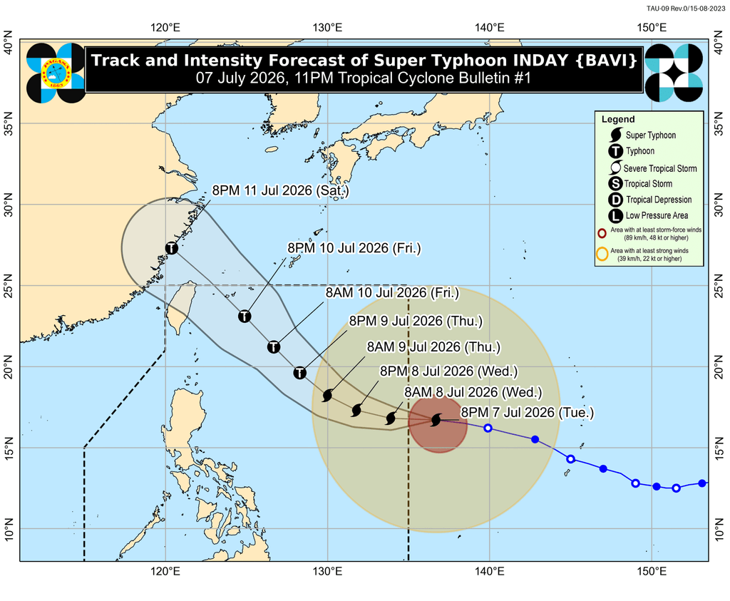
In a separate advisory issued at 11 pm on Tuesday, PAGASA said Inday will trigger moderate to heavy rain (50-100 millimeters) in Batanes from Thursday evening, July 9, to Friday evening, July 10.
Meanwhile, the enhanced southwest monsoon will be causing rain in more areas. Here is the latest three-day rainfall outlook for the habagat:
Tuesday evening, July 7, to Wednesday evening, July 8
- Moderate to heavy rain (50-100 mm): Sultan Kudarat, Sarangani
Wednesday evening, July 8, to Thursday evening, July 9
- Moderate to heavy rain (50-100 mm): Occidental Mindoro, Palawan, Antique, Negros Occidental
Thursday evening, July 9, to Friday evening, July 10
- Heavy to intense rain (100-200 mm): Occidental Mindoro, Antique
- Moderate to heavy rain (50-100 mm): Zambales, Bataan, Metro Manila, Cavite, Batangas, Palawan, Guimaras, Iloilo, Negros Occidental, Negros Oriental, Lanao del Norte, Lanao del Sur
Floods and landslides are likely.
On Wednesday, moderate to rough sea conditions will already be experienced in some seaboards due to both Inday and the enhanced southwest monsoon.
Up to rough seas (small vessels should not venture out to sea)
- Southeastern seaboard of Isabela; northern seaboard of Aurora; northern and eastern seaboards of Northern Samar; eastern seaboards of Eastern Samar, Dinagat Islands, Siargao-Bucas Grande Islands, and Surigao del Sur; eastern and southern seaboards of Davao Oriental – waves up to 4 meters high
- Eastern seaboards of Batanes, Cagayan, Albay, and Sorsogon; northern and eastern seaboards of Catanduanes; remaining seaboard of Isabela – waves up to 3.5 meters high
- Remaining seaboard of Aurora; northern and eastern seaboards of Polillo Islands; northern seaboards of Camarines Norte and Camarines Sur – waves up to 3 meters high
Up to moderate to rough seas (small vessels should take precautionary measures or avoid sailing, if possible)
- Northern seaboard of mainland Quezon; remaining seaboards of Batanes and Cagayan – waves up to 2.5 meters high
- Southern seaboards of Southern Leyte and Bohol; western seaboard of Surigao del Norte; western seaboard of Kalayaan Islands – waves up to 2 meters high
According to PAGASA, Inday may be downgraded to a typhoon by Thursday afternoon or evening — still a strong tropical cyclone nonetheless.
Inday is the country’s ninth tropical cyclone for 2026, and the second for July. The weather bureau earlier said two to four tropical cyclones may form within or enter PAR during the month. – Rappler.com


You May Also Like

Fidelity Solana ETF Filing Keeps Custody Questions At The Centre Of The SOL Fund Race

Phantom and Hyperliquid Urge CFTC to Update Rules for Onchain Derivatives

Bitcoin, Gold, and U.S. Stocks Dive as Trump Pledges to Hit Iran ‘Extremely Hard’