Severe Tropical Storm Domeng slightly intensifies over Philippine Sea
MANILA, Philippines – Severe Tropical Storm Domeng (Jangmi) strengthened a bit over the Philippine Sea on Saturday morning, May 30.
Domeng’s maximum sustained winds increased from 95 kilometers per hour to 100 km/h, said the Philippine Atmospheric, Geophysical, and Astronomical Services Administration (PAGASA) in its 11 am bulletin on Saturday. The severe tropical storm’s gustiness is now up to 125 km/h from 115 km/h.
By Saturday evening or Sunday morning, May 31, Domeng could intensify into a typhoon. Under PAGASA’s classification, a typhoon has maximum sustained winds of 118 to 184 km/h.
As of 10 am on Saturday, Domeng was located 875 kilometers east of Northern Luzon, moving northwest at 20 km/h. It is expected to remain far from Philippine landmass, and may eventually recurve towards Japan.
But Domeng’s trough or extension is currently causing scattered rain and thunderstorms in Eastern Visayas, Sorsogon, and Masbate. Flash floods and landslides are possible.
PAGASA added that Domeng will be enhancing the southwest monsoon, which has already started, as announced by the weather bureau also on Saturday morning.
PAGASA issued a separate rainfall advisory for the southwest monsoon at 11 am on Saturday, covering a 48-hour period and five provinces:
Sunday noon, May 31, to Monday noon, June 1
- Moderate to heavy rain (50-100 millimeters): Palawan, Occidental Mindoro, Antique
Monday noon, June 1, to Tuesday noon, June 2
- Moderate to heavy rain (50-100 mm): Palawan, Occidental Mindoro, Antique, Iloilo, Guimaras
Floods and landslides are possible.
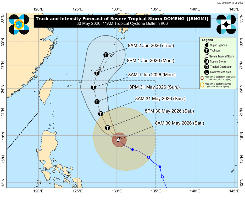
Meanwhile, it remains “less likely” for tropical cyclone wind signals to be raised, given Domeng’s distance from land. But PAGASA is not ruling out the possibility of extreme Northern Luzon being placed under a wind signal.
The enhanced southwest monsoon and the periphery or outer bands of the severe tropical storm will also bring strong to gale-force gusts to these areas:
Saturday, May 30
- most of Visayas, Batanes, Cagayan, Pangasinan, Zambales, Bataan, Tarlac, Nueva Ecija, Bulacan, Calabarzon, Mimaropa, Bicol, Zamboanga del Norte, Misamis Oriental, Camiguin, Agusan del Norte, Surigao del Norte, Dinagat Islands, Sarangani, Davao Occidental, Davao Oriental
Sunday, May 31
- most of Visayas, Batanes, Cagayan, Calabarzon, Mimaropa, Bicol, Zamboanga del Norte, Misamis Occidental, Misamis Oriental, Camiguin, Agusan del Norte, Dinagat Islands, Surigao del Norte, Sarangani, Davao Occidental, Davao Oriental
Monday, June 1
- most of Visayas, Batanes, Babuyan Islands, Calabarzon, Mimaropa, Bicol, Camiguin, Dinagat Islands, Davao Occidental, Davao Oriental
Conditions in certain seaboards will remain dangerous in the next 24 hours.
Up to rough seas (small vessels should not venture out to sea)
- Eastern seaboards of Batanes and Babuyan Islands – waves up to 3.5 meters high
- Remaining seaboards of Batanes; northern seaboard of Babuyan Islands; eastern seaboards of Cagayan, Isabela, and northern Aurora – waves up to 3 meters high
Up to moderate seas (small vessels should take precautionary measures or avoid sailing, if possible)
- Remaining seaboards of Babuyan Islands, Cagayan, and Aurora; northern and eastern seaboards of Polillo Islands, Catanduanes, and Northern Samar; eastern seaboards of northern Quezon and Eastern Samar; northern seaboards of Camarines Norte and Camarines Sur – waves up to 2.5 meters high
- Seaboards of Ilocos Norte, Southern Leyte, Surigao del Norte, and Dinagat Islands; eastern seaboard of Davao Occidental; southern seaboard of Bohol; northern seaboard of Camiguin; eastern and southern seaboards of Davao Oriental – waves up to 2 meters high
Domeng is likely to exit PAR on Monday, June 1. It is the country’s fourth tropical cyclone for 2026, and the second for May.
PAGASA is expected to soon declare the start of the rainy season, which typically begins in the second half of May or the first half of June. – Rappler.com


You May Also Like

Yiwu Agent: Smarter Sourcing in China

ChatGOT Review 2026: Free AI Chatbot (No Sign-up)

Bitcoin Underperforms Stocks: Why BTC Is Missing the AI-Led Risk Rally